Treating COVID with Bike Lanes: Design, Spatial, and Network Analysis of ‘Pop-Up’ Bike Lanes in Paris
By Marcel Moran
Many cities responded to the COVID-19 pandemic by erecting new bike lanes (Kraus and Koch 2021), but there has been little scrutiny of where these lanes are being installed, how they relate to pre-COVID networks, what street uses they replaced, and their design characteristics (such as their level of physical protection and bi-directionality).
Questions
This study pursues these questions in the context of Paris, France, a city currently in the midst of a large-scale transformation of its streets (Sisson 2020). Indeed, Mayor Anne Hidalgo champions the ‘15-minute city’ (‘ville du quart d’heure’), a vision wherein Parisians can reach a range of destinations (school, work, leisure, groceries, etc.) quickly, safely, and sustainably (O’Sullivan 2020).
This analytical approach moves past evaluating bike lanes purely in terms of length (e.g. ‘100 KM of new lanes’), and adds design, spatial, and network context. These features are relevant because prior research indicates that protected bike lanes (compared to those only painted) both reduce collisions and increase cycling (Marshall and Ferenchak 2019; Monsere et al. 2014), and that connectivity – to what extent different bike lanes intersect – plays a crucial role in their overall attractiveness to riders (Furth, Mekuria, and Nixon 2016). Furthermore, bike lanes that are bi-directional provide double the benefit to cyclists, though that attribute is often not reflected in network evaluations.
Methods
Paris’s municipal government maintains an open-data website, which includes a file covering its varied bicycle infrastructure installed between 2005 and February, 2020 (“Réseau des Itinéraires Cyclables” 2021). In combination with another dataset on its COVID-19 pop-up bike lanes, (“Pistes Cyclables Temporaires” 2021) this delineates the following six categories:
- Painted Bike Lanes;
- Protected Bike Lanes (including separated bike paths);
- ‘Pop-Up’ Bike Lanes (those installed quickly with staggered concrete blocks and plastic posts in response to COVID-19);
- Sharrows (painted bike icons in mixed traffic lanes);
- Pedestrianized Areas (streets with fencing and signage which prohibit automobiles); and
- Bus Lanes, which also allow cyclists.
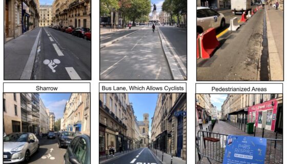
Three categories of bike infrastructure in Paris were excluded from the following analyses: 1) bus lanes which also allow cyclists, 2) sharrows, and 3) pedestrianized areas. The reason for these exclusions stems from on-the-ground observations over months of use. First, the bus lanes that allow cyclists generally provide little improvement over normal traffic lanes, both because bus service is frequent and that taxis are also allowed use of such lanes. This results in cycling conditions with little separation from vehicles. Sharrows and pedestrianized areas are left out because the former provides exceedingly little benefit to cyclists, and because pedestrianized areas in Paris are both very often impossible for cyclists to use (due to heavy pedestrian traffic) and also are often temporally restricted, in that many hours of the day they are not closed to car traffic. This step narrows the data to painted lanes, protected lanes, and pandemic-specific pop-up lanes, an important filtering of Paris’s bike infrastructure that is missing from nearly all municipal, academic, and media reports. Of these three remaining categories of bicycle infrastructure in Paris, the painted lanes provide the least safety and comfort for cyclists (given there is no physical barrier separating them from traffic), followed by pop-up lanes (most of which use a combination of concrete blocks and plastic posts to form a barrier), and lastly the standard protected lanes, which include continuous separation from traffic with in-ground concrete slabs.
Data on these lanes not only include their location, length, and category, but also the year in which each lane segment was installed (for 74% of the entire pre-COVID network), as well as whether or not each is bidirectional. The bi-directionality attribute was missing from the pop-up lanes, and added manually based on in-person observation and review of images from Google Street View. Google’s database of images also enabled the determination of what street use (on-street parking or traffic lane) preceded each pop-up lane. Every bike lane was also evaluated as to how many other bike lanes it connects to (or intersects with) at the time each segment was installed. This allows for a temporally-specific connectivity measure, which generates a picture of how network connectivity has changed longitudinally.
More broadly, the process of analyzing bicycle lanes both by year of installation and category is applicable to other cities where records are available. It is essential for researchers to combine these datasets with local knowledge; bike lanes vary in quality (and naming conventions), and removing types likes sharrows ensures more accurate representations of a network in total. Indeed, this study in part draws inspiration from work by Firth and colleagues (2021), who mapped bike lanes in Vancouver, British Columbia, over time.
Findings
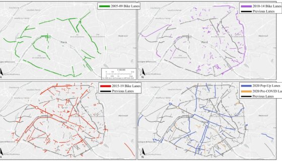
From 2005 to the close of 2020, Paris installed 503 kilometers of bike lanes, with the majority coming in the form of protected lanes (332 kilometers, 66%), followed by painted lanes (124 kilometers, 25%), and pop-up lanes, in 2020 (47 kilometers, 9%). Mapping the expansion of bike lanes in Paris over four discrete time periods (2005-2009, 2010-2014, 2015-2019, and 2020) demonstrates temporal patterns, and puts the lanes erected quickly as a pandemic response into spatial context. Fifteen years of bike lanes proceeded with the construction of a ring of lanes surrounding Paris’s periphery, followed by additional, shorter lanes clustered in western arrondissements (districts), major east to west bike lanes (including along the Seine River), and, due to COVID-19, long bike-lane corridors that provide cyclists routes from the city’s periphery to its inner core (and vice versa).