Skip to content
    • About CED
    • Academics
    • For Students
    • CED
      • About CED
        • Community + Values
        • People at CED
        • Meet CED Alums
        • Our Spaces
        • Our History
        • Work at CED
        • Giving
        • Contact Us
      • Academics
        • Undergraduate Majors + Minors
        • Graduate Programs
        • Concurrent Graduate Degrees
        • Certificates
        • Summer Programs
        • Study Abroad
      • Admissions
        • Undergraduate Admissions
        • Graduate Admissions
        • Fees + Financial Aid
      • Undergraduate Advising
        • Newly Admitted Students
        • Forms + Policies
        • Major + Minor Requirements
        • Prepare for Graduation
        • Academic Progress Report
      • News + Events
        • News
        • Events
      • Research + Design
        • Affiliated Research Centers
        • Climate Solutions
        • Equity + Social Justice
        • Technology + Material Innovations
        • Design Excellence
        • Publications
        • Environmental Design Archives
        • Student Work
      • Student Resources
        • Student Organizations
        • Student Support
        • Awards, Scholarships, Fellowships
        • Academic Student Employment
        • Student Fees and Waivers
        • IT + Computing
        • Fabrication + Materials
        • Environmental Design Library
        • Building Safety
        • Facility Services
        • Careers + Opportunities
    • ARCH
      • About Architecture
        • Commitment to Diversity
        • Accreditation and Licensure
      • People
      • Degrees + Admissions
        • Master of Architecture (MArch)
        • Master of Advanced Architectural Design (MAAD)
        • Master of Science in Architecture
        • PhD in Architecture
        • Bachelor of Arts
        • Minors
      • Gallery
      • Courses
      • Advising
    • LAND
      • About LAEP
      • People
      • Degrees + Admissions
        • Master of Landscape Architecture
        • PhD
        • Bachelor of Arts
        • Minor in Landscape Architecture
      • Gallery
      • Advising
    • CITY
      • About DCRP
      • People
      • Degrees + Admissions
        • Master of City Planning
        • PhD
        • Bachelor of Arts in Urban Studies
        • Minor in City Planning
        • Minor in Geospatial Information Science & Technology
      • Gallery
      • Advising
    • IURD
      • About IURD
      • People
      • IURD Research Projects
      • Abbey Master of Real Estate Development + Design (MRED+D)
        • About Abbey MRED+D
        • Abbey MRED+D Admissions
        • Abbey MRED+D Courses
        • People
      • Master of Urban Design (MUD)
        • People
      • BA in Sustainable Environmental Design
      • Advising
  • CED
    • About CED
      • Community + Values
      • People at CED
      • Meet CED Alums
      • Our Spaces
      • Our History
      • Work at CED
      • Giving
      • Contact Us
    • Academics
      • Undergraduate Majors + Minors
      • Graduate Programs
      • Concurrent Graduate Degrees
      • Certificates
      • Summer Programs
      • Study Abroad
    • Admissions
      • Undergraduate Admissions
      • Graduate Admissions
      • Fees + Financial Aid
    • Undergraduate Advising
      • Newly Admitted Students
      • Forms + Policies
      • Major + Minor Requirements
      • Prepare for Graduation
      • Academic Progress Report
    • News + Events
      • News
      • Events
    • Research + Design
      • Affiliated Research Centers
      • Climate Solutions
      • Equity + Social Justice
      • Technology + Material Innovations
      • Design Excellence
      • Publications
      • Environmental Design Archives
      • Student Work
    • Student Resources
      • Student Organizations
      • Student Support
      • Awards, Scholarships, Fellowships
      • Academic Student Employment
      • Student Fees and Waivers
      • IT + Computing
      • Fabrication + Materials
      • Environmental Design Library
      • Building Safety
      • Facility Services
      • Careers + Opportunities
  • ARCH
    • About Architecture
      • Commitment to Diversity
      • Accreditation and Licensure
    • People
    • Degrees + Admissions
      • Master of Architecture (MArch)
      • Master of Advanced Architectural Design (MAAD)
      • Master of Science in Architecture
      • PhD in Architecture
      • Bachelor of Arts
      • Minors
    • Gallery
    • Courses
    • Advising
  • LAND
    • About LAEP
    • People
    • Degrees + Admissions
      • Master of Landscape Architecture
      • PhD
      • Bachelor of Arts
      • Minor in Landscape Architecture
    • Gallery
    • Advising
  • CITY
    • About DCRP
    • People
    • Degrees + Admissions
      • Master of City Planning
      • PhD
      • Bachelor of Arts in Urban Studies
      • Minor in City Planning
      • Minor in Geospatial Information Science & Technology
    • Gallery
    • Advising
  • IURD
    • About IURD
    • People
    • IURD Research Projects
    • Abbey Master of Real Estate Development + Design (MRED+D)
      • About Abbey MRED+D
      • Abbey MRED+D Admissions
      • Abbey MRED+D Courses
      • People
    • Master of Urban Design (MUD)
      • People
    • BA in Sustainable Environmental Design
    • Advising
  • About CED
  • Academics
  • For Students
  • About CED
  • Academics
  • For Students
BACK
BACK
NEWS

The potential of remote sensing to improve landscape research

Jan 5, 2017
Changes in vegetation patches in a portion of restored wetland on Sherman Island, CA

Remote sensing technology is increasingly penetrating our lives — from satellite images underlying everyday routes on Google Maps and smartphones to the ever more familiar buzzing of camera-equipped “toy drones” flying above neighborhoods. The technology has leaped from early air balloon photography and cameras deployed on pigeons in the late 19th century to satellite, aircraft and now unmanned vehicle sensors delivering unprecedented spatial detail and options for custom data collection. The types and amounts of information collected by remote sensing platforms continue to expand, creating new opportunities to investigate the reciprocal human-nature interactions transforming the global landscape.

In landscape research and planning, the most commonly used remote sensing datasets are aerial and satellite images that historically have been limited for site-scale research. Their major applications — mapping, measuring, monitoring and modeling landscape properties and changes — rely substantially on human or machine interpretation of various ground features and cover types. This may be difficult due to coarse spatial resolution obscuring recognizable landscape features and/or limited temporal frequency of historically available data.

More recently, high-resolution landscape data have been increasingly available from state-of-the-art commercial satellites, low-flying aircrafts, unmanned aerial vehicles and laser-based light detection and ranging (lidar) sensors. These data provide novel insights into “mesoscales” where a high level of spatial detail is needed for research, yet where the larger spatial extents prohibit detailed and repeated ground surveys. Understanding ecological processes at these scales is key to many critical issues in landscape planning, conservation and environmental design. Fortunately, we are now seeing more rigorous and innovative strategies being applied for analyzing remote sensing data and linking with other ground-based and non-spatial information.


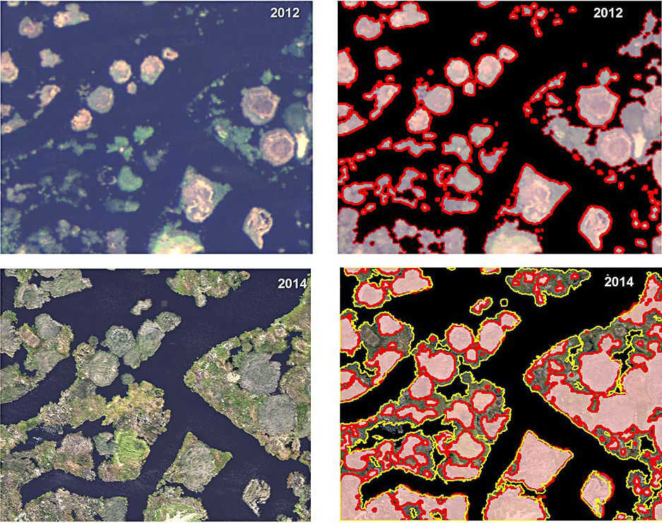
Understanding the outcomes of ecological restoration in sensitive wetland regions

Wetlands are important targets in ecological restoration. They provide protection against coastal flooding, pollution remediation, supporting biological diversity and various aesthetic and recreational qualities. Wetland ecosystems may also sequester greenhouse gases through plant growth and soil microbial processes. However, measuring these benefits is difficult — wetland environments are often spatially complex, hard to navigate, and often inhabited by sensitive plant and animal species easily disturbed by human presence.

To address these challenges, high-resolution remote sensing allows monitoring wetland status at spatial detail revealing microhabitats shaped by natural processes and human effects. Monitoring is especially critical at early stages of post-restoration wetland recovery to understand how recovery may be affected by the initial site designs, to evaluate whether the sites follow their intended trajectories or harbor any unwanted hazards (such as aggressive exotic species), and to inform adaptive strategies to manage existing sites and design the future ones. Several projects in my lab are using remote sensing to understand post-restoration wetland dynamics and ecosystem services in California’s Sacramento-San Joaquin Delta — the region playing a critical role in fresh water supply to agricultural, industrial and residential demands of the state.


Coupled thermal-vegetation patterns as indicators of urban environment and socioeconomic issues

Among various benefits of urban vegetation, local cooling and improvement of thermal comfort are especially well-known and important given increasing heat loads and dominance of built-up surfaces in cities. What is not well understood, however, is how these benefits vary with different vegetation types, management practices and urban morphologies. To facilitate this task, we use repeatedly collected optical and thermal satellite imagery to measure green vegetation cover and surface temperature and to develop metrics showing how different parts of the city deviate from “average” conditions. Because suitable satellite-based products are often relatively coarse in spatial resolution (grain), ancillary high-resolution imagery aids in interpreting these patterns from a “birds-eye” perspective.

Because these metrics show relative, rather than absolute, distributions of urban conditions, they can be compared among different urban regions and other environmental, social and economic variables to better understand the drivers and conditions of human settlements, the hazards associated with extremely “hotter, less green” conditions, and differential access to urban amenities. Our current research is testing which remotely sensed metrics are especially sensitive to demographic and socioeconomic characteristics to provide cost-effective indicators for monitoring urban areas worldwide, including regions with scarce data.


The promise of remote sensing

Rapidly advancing remote sensing technology offers powerful capabilities to assess landscape changes at different scales and investigate their relationship to various intrinsic and external determinants. This potential can be especially useful in complex areas where massive “ground” data acquisitions are too costly and impractical, such as urban regions, restored wetlands and other human-designed and managed landscapes. High-resolution imagery is especially promising to facilitate cost-effective yet informative monitoring at the scale of individual sites and thus should be more rigorously utilized to inform landscape planning, design and management.

Photo Modal

Berkeley home page

230 Bauer Wurster Hall #1820 Berkeley, CA 94720-1820

230 Bauer Wurster Hall #1820 | Berkeley, CA 94720-1820

  • Contact
  • Work at CED
  • Faculty + Staff
  • Linkedin
  • Accessibility
  • Land Acknowledgment
  • Privacy
  • Nondiscrimination
  • Credits

© 2025 UC Regents; all rights reserved.

    • DONATE NOW
    • ARCH
    • CITY
    • LAND
    • IURD
Berkeley home page
  • ARCH
  • CITY
  • LAND
  • IURD
  • DONATE NOW
  • Contact
  • Work at CED
  • Faculty + Staff

230 Bauer Wurster Hall #1820 Berkeley, CA 94720-1820

  • Accessibility
  • Land Acknowledgment
  • Privacy
  • Nondiscrimination
  • Credits

© 2025 UC Regents; all rights reserved.